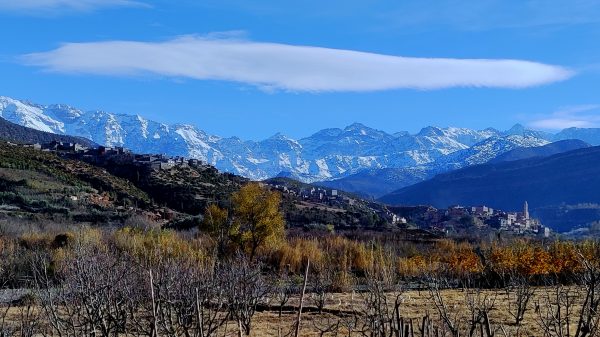
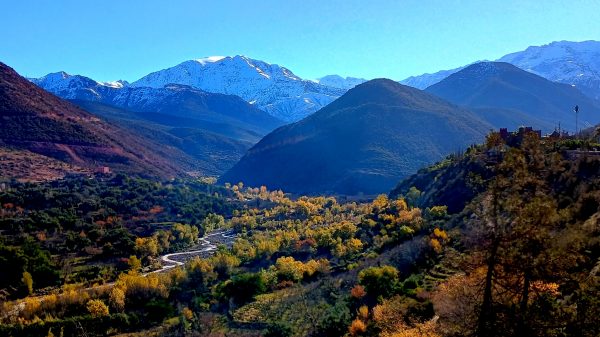
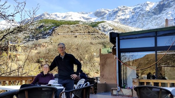
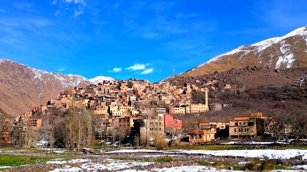
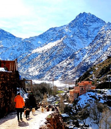
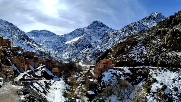
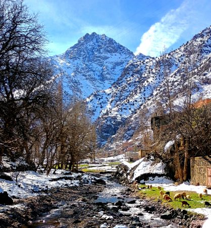
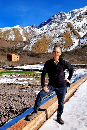
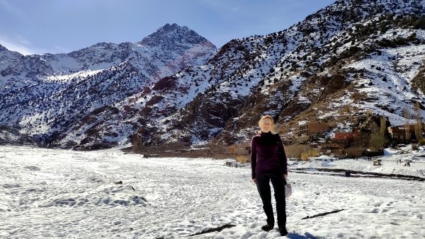
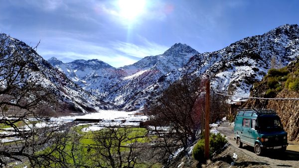
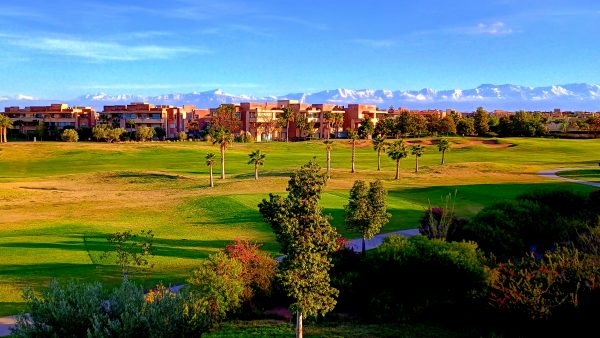
A perfect day to head into the foothills of the High Atlas Mountains! Gorgeous snow capped views along the route.We navigate the mountain roads — above the Ait Mizane Valley — to the village of Imlil.We find a rooftop cafe in Imlil for some coffee before beginning our hike up to the snowy High Atlas Mountains.We trek – climbing the cascading waterfalls for about an hour to the traditional Amazigh (Berber) village of Aroumd — on a tourist office postcard perfect day. (this is our photo!)A herder follows his sheep to the valley floor through Aroumd, with Mount Toubkal presiding — North Africa’s highest peak at 4,167 m (13,671 ft).A panoramic photo of Mount Toubkal. That is ‘panoramic’ indeed! The local children have rounded up some downhill skis and found an area to have snow-play fun in the high altitude sunshine.We caught up with the sheep grazing peacefully on a freshly watered green meadow.Enjoying the sunshine on the last day of 2025……And appreciating we’ve explored another corner of the world near Toubkal National Park.We found a great spot for having a picnic lunch and savored the view — near Aroumd with majestic Mount Toubkal as a backdrop.Back at our condo’s balcony in Marrakech with its view of the snow capped range — we will remember our fabulous journey to the High Atlas Mountains!
We drove to nearby Grindelwald and took the Eiger Express gondola to see the Eiger, Monch, & Jungfrau. That is the Ogre with the Monk in between protecting the Young Maiden, or so the legend goes.The sun is just illuminating the ridges. Would you look at those glaciers?We start hiking down into the sunshine. That is the village of Murren nestled on the edge of the cliff behind me.We come across this place to take a break with a view of the Wetterhorn. That ridge far on the distant horizon is where we biked to yesterday: Gross ScheideggToday we are first heading to Kleine Scheidegg, nestled in this valley.The weather has warmed up nicely and I am thirsty!And we have worked up an appetite.Wow! This is a Swiss Rosti. A pile of potatoes, with bacon & melted cheese, topped with a fried egg. Hearty mountain hiking fare.We continue to enjoy the Eiger’s North Face and the Moch as we hike some more.As we hike down back to Grindlewald, we ask why some mountains are called “horns”? Seems that they have been carved by 3 glaciers which leaves the horn in the middle. To visualize, pick up 3 glasses in one hand – that empty space where the 3 meet is where the glaciers did not carve away the rock.The Eiger Express gondolas (hold 26 persons!) with the Wetterhorn. We are happy there is not a sanction out on us and that we have not run into Clint Eastwood or George Kennedy today. Ha Ha Ha. But we would have bought them a beer…Returning to Grindelwald on this how-could-it-be-better crystal clear fall day. Pure Satisfaction.
Sunrise from our apartment in Meiringen, Switzerland – the start of a beautiful day!Listening to some deductive reasoning in Conan Doyle Place from Sherlock Holmes. Elementary, my dear Watson…Conan visited Meiringen and he came to use nearby Reichenbach Falls in “The Final Problem”.Correct reproduction from original blue prints of 221B Baker Street, the parlor of Sherlock-Holmes. The museum gives us details of Conan, Sherlock, and Watson as well as artifacts from that era.Reyna Bistro Cafe – time for a coffee break!Cable Car up to Reuti is included in our Haslital visitor card so we rode up for a look back on the town and……We walked the Panorama-Weg, enjoying the countryside and views of Wetterhorn mountain.Zooming in on the beautiful Wetterhorn and it’s glacier.The Swiss precisely stack their firewood so that it is a work of art.Cows are hanging around Badesee – the lake is a reflecting mirror pond this afternoon.This little restaurant on Badesee is open today – tomorrow it closes for the season – we are able to enjoy some hot food and the pleasant fall day.It was about a 2-mile hike to Badesee form the cable car – a great leisurely destination. We retraced our route back home.Another great apartment – this was perhaps our largest and very comfy! Time to enjoy the balcony.
We took the Kreuzboden gondola from our town to enjoy the views….hopefully.We spent several hours watching the clouds play on the mountains, while we played on the lake.A fun little waterfall on the Yoga/Wellness weg/trail.Enjoying the gorgeous peaks!Is this the Weissmies behind me? I am swinging on a fun suspension bridge across a ravine.Loved the colorful lichen covered rocks. A bright lime green in the sunshine. The sun shines – yeah!Our penthouse apartment in the center of town is a relaxing retreat!
Our neighboring car free village of Saas-Fee was worth exploring. These are some original homes still preserved. They are made out of larch wood which is very dense and long lasting. Notice also the stone mushrooms the houses are set on their foundations which kept them dry and rodent free.From the bus stop, we took the Hannig gondola lift to this gorgeous patio. We enjoyed cappuccinos with a home made plum cake. What a way to spend your day surrounded by beauty.The new Hannig Playground felt like an infinity pool. Wouldn’t it be fun to be a kid to play here? Well maybe we try out the swing…Enjoying some of the 13 peaks over 4,000 meters from the Glacier Swing. The Dom peak (to the right, not in photo) at 4,545 m (14,911′) is the highest Alp all in Switzerland, 3rd highest in all the Alps – right after Monte Rosa which we saw yesterday.The Saas Fee Trail: We are going to “let the high- altitude air, nature and the sheer peacefulness make their effect on us”. A beautiful south facing slope to traverse on the start of our hike back to town, the longer route.We are about half way down – maybe? …sign is in minutes but we linger more… You can see Saas Fee in the valley below. In the end, we hiked 6 miles and longer than the 2 hours indicated on the sign.The stones glistened even when dry (mica? silver?) and the sound of water falling was nice to appreciate. We had our picnic lunch near here to enjoy all of the variety around us.We are “consciously enjoying the impressions of these surroundings”. Every corner seems to have a different view. Loving the fall colors!Our newest family member is a week old. We made a good lifetime wish for her by adding stones to this tower. The Fee (Fairy) glacier will melt, and the Fee Vispe river will wash this ephemeral pile of rocks to the Saastal Valley and beyond… Who knows where our journeys are going to take us?The Fee river carrying away the ice melt from the Fee glacier as it heads into the Saas Fee village.An old water mill on the Saas-Fee Trail was very picturesque.Larch Tree forest in all it’s beautiful fall color. We saw some golden aspens mixed in as well.It has been a beautiful journey in the swiss glaciers!
The Swiss Alps! The Pennine Alps on the border with Italy.Our first view of the Matterhorn from Zermatt around 8:30 am. Beautiful early morning light made our getting up early worth the effort.We have taken the underground funicular Sunnegga to enjoy the Matterhorn today. Zermatt is car free so you park out of town and take a train in. From our apartment it took us about 2 hours to get to this starting point of our hike.We start on the marmot trail which follows the next lift up about 1,000′ – morning stairmaster with a view!The Stellisee is the first lake on the 5-Lake-Trail. Such a gorgeous and clear day – how fortunate we are today. We are wishing the breeze on the lake to subside…We lingered here for almost an hour and we got the best possible view ever! We are very happy and this was definitely worth getting up early to be one of the first here this morning.Stellisee reflecting the Matterhorn. Can you believe this is real? It felt a bit surreal to have this experience.We walked above Stellisee to enjoy views of the valley, fall colors, and the excellent panorama. And behind us …Monte Rosa is a massif comprised of several peaks, including Dufourspitze- 15,203 ‘ (4,634 meters) -claiming the title of Switzerland’s highest peak. There are several large glaciers here too, including the Gorner but this is probably a photo of Findel glacier.We could not resist zooming in on the peak of the snaggletooth Matterhorn peak. Because really, how many times could you get this photo?!?! The height is 14,685 ‘ , the 6th tallest Alp!The next lake we stopped at was Grindjisee with some pretty reflections. We enjoyed the larch trees as they are changing color and ready to drop their needles.The water of Moosjisee was very glacial – teal sky color!Our parting view of the Matterhorn. We had a great day enjoying this iconic slice of Switzerland.
We venture higher in elevation on another blue sky day to enjoy this view of the Dolomites!We took a bus from Lajen to Ortisei, then we took a gondola and the Seceda cable car.Many people are enjoying this beautiful day. This is the Val Gardena valley, is part of the UNESCO world heritage site.The incredible view point at the summit shows all the alpine peaks we can see in the 360 degrees. It is a clear enough day that we could see Grossglockner in Austria as well as some of the tallest Swiss Alps.We shared photo taking before starting out on the Seceda Rim Hike.The rugged Seceda Geisler Gruppe – so picturesque with the snow.There was a bite to the wind but it made for some very photogenic opportunities.We drop into the valley from the top and there is less snow on the trail.Baita Troier Hütte: this Mountain hut is our lunch destination.It is situated in the National Park Puez Odles at an altitude of 2250 meters and it has a wonderful view to the surrounding Dolomites.A fabulous location to look over the valley and enjoy some Italian spirits.Lunch of fried potatoes, Tyrolean bacon, with fried eggs – very satisfying mountain hiking food!Well signed hiking routes to get us back to the cable car. Signs are labeled in minutes not distance. The next sign generally has the same time to the destination which we found very amusing.Maybe we should take another break at the Daniel Hütte?An incredible day visiting Seceda – a special place in the Alps!
We are on the aptly named Panorama Lift from Seiser Alm to explore the Alpe di Siusi. We have gotten up early to drive and park in Compatsch by 9am – we don’t want to miss much of this blue sky day!The clouds are still playing with the Santerspitz peaks as we start our hike in the dramatic dolomites. We are at around 6,500 foot elevation.The Navigator keeps us on the correct route. A little bit of mud but mostly clear trails!It feels more like spring than fall but still a beautiful day to be in the high meadows.A water supply pond reflects Croda del Zirmei and the blue blue sky.Isn’t this picturesque?Appreciating the Croda del Zirmei as it dominates our hike.This is for our new great niece who we are welcoming into the world from this gorgeous location in Italy. Wishing her a wonderful life, full of happiness!We toast to the good life with Italian cappuccinos, South Tyrolean apple strudel, and sunshine at the Mahlknecht hütte.We had a fabulous 6-mile hike on this gorgeous day. We hiked across the meadows, caught the Florian lift down to Saltria, and took the bus back to our car.